Item (Aerial_2018_SID)
Item Card (XML) | Package Info| ID | 2f65797dcad04a6caebfa76161300f06 |
| Owner | gisadmin@ci.salinas.ca.us |
| Uploaded | Sep 17, 2021 |
| Modified | Jun 21, 2022 |
| Thumbnail |
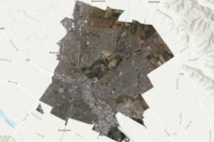
|
| GUID | N/A |
| Name | N/A |
| Title | Aerial_2018_SID |
| Type | Map Service |
| Type Keywords | ArcGIS Server, Data, Map Service, Metadata, Service |
| Description | Product: This orthoimagery data set includes 3-inch 8-bit 4-band (RGBN) digital orthoimage mosaics in MrSID format (20:1 compression). Geographic Extent: The AOI covers approximately 28 total square miles of the City of Salinas in the State of California. Dataset Description: City of Salinas, CA 2018 Orthoimagery project called for the planning, acquisition, processing, and derivative products of imagery data to be collected at a ground sample distance (GSD) of 0.25 foot. Project specifications are based on the U.S. Geological Survey National Geospatial Program Base Ortho Specification, Version 1.0. The data were developed based on a horizontal projection/datum of NAD83 (2011) California State Plane Coordinate System, Zone 4, US Survey Feet. Orthoimagery data were delivered as stereo imagery pairs in GeoTIFF format, 131 individual 0.25-foot 2,640 feet x 2,640 feet 8-bit, 4-band (RGBN) GeoTIFF tiles, and a 0.25-foot 8-bit, 4-band (RGBN) 20:1 compressed MrSID mosaic. Ground Conditions: Aerial photography was captured during the summer of 2018, while no snow was on the ground and rivers were at or below normal levels. In order to post process the imagery data to meet task order specifications and meet horizontal accuracy guidelines, Quantum Spatial, Inc. utilized a total of 16 surveyed control points throughout the project area to assess the horizontal accuracy of the data. These checkpoints were not used to calibrate or post process the data. |
| Tags | 0.25-foot orthoimage, MrSID, rectified photograph, rectified image, orthophoto, natural color orthophoto, orthoimage, image map, State of California, City of Salinas, Monterey County |
| Snippet | This dataset depicts geographic features on the surface of the earth. It was created to current imagery data for the project area. |
| Extent | [-121.72159287841602, 36.615563232178694] - [-121.55442149169727, 36.75258432659267] |
| Spatial Reference | NAD_1983_StatePlane_California_IV_FIPS_0404_Feet |
| Access Information | Quantum Spatial, Inc. & City of Salinas, Public Works Department, GIS Division |
| Classification | N/A |
| License Information | Quantum Spatial, Inc. Use Limitations: None. However, users should be aware that temporal changes may have occurred since this data set was collected and that some parts of these data may no longer represent actual surface conditions. Users should not use these data for critical applications without a full awareness of their limitations. City of Salinas Use Limitations: Disclaimer_Warranties/Accuracy: GIS data in this map are provided as an information resource for the public use and are provided "AS IS" without warranties of any kind, expressed or implied. To the fullest extent permissible under applicable law, THE CITY OF SALINAS DISCLAIMS ALL WARRANTIES, EXPRESSED OR IMPLIED, INCLUDING BUT NOT LIMITED TO, IMPLIED WARRANTIES OF MERCHANTABILITY, FITNESS FOR A PARTICULAR PURPOSE AND TITLE TO ANY OF THE MATERIALS PROVIDED. The City of Salinas does not warrant that the functions contained in the materials will be uninterrupted or error-free. The City of Salinas does not warrant or make any representations regarding the use of the results in this dataset, or through links to other data, in terms of their correctness, accuracy, reliability or otherwise. The USER assumes the entire cost of all necessary servicing, repair or corrections. THE CITY OF SALINAS SHALL NOT BE HELD LIABLE FOR ANY IMPROPER OR INCORRECT USE OF MATERIALS OR INFORMATION PROVIDED AND ASSUMES NO RESPONSIBILITY FOR ANY USERS' USE OF THEM. IN NO EVENT SHALL THE CITY OF SALINAS BE LIABLE FOR ANY DAMAGES, WHETHER DIRECT, INDIRECT, INCIDENTAL, SPECIAL, EXEMPLARY OR CONSEQUENTIAL (INCLUDING, BUT NOT LIMITED TO, BUSINESS INTERRUPTION OR LOSS OF USE, DATA, OR PROFITS) REGARDLESS OF CAUSE, AND ON ANY THEORY OF LIABILITY, WHETHER IN CONTRACT, STRICT LIABILITY, OR TORT (INCLUDING NEGLIGENCE OR OTHERWISE) ARISING IN ANY WAY OUT OF THE USE OF THIS DATA AND INFORMATION CONTAINED WITHIN THE DATASET, EVEN IF ADVISED OF THE POSSIBILITY OF SUCH DAMAGE.THIS DISCLAIMER OF LIABILITY APPLIES TO ANY DAMAGES OR INJURY, INCLUDING BUT NOT LIMITED TO THOSE CAUSED BY ANY FAILURE OF PERFORMANCE, ERROR, OMISSION, INTERRUPTION, DELETION, DEFECT, DELAY, COMPUTER VIRUS, COMMUNICATION LINE FAILURE, THEFT, OR DESTRUCTION OF DATA, WHETHER FOR BREACH OF CONTRACT, TORTIOUS BEHAVIOR, NEGLIGENCE, OR UNDER ANY OTHER CAUSE OF ACTION. Users are encouraged to consult with appropriate and accredited professional advisors for advice concerning specific matters before making any decision, and the City of Salinas disclaims any responsibility for positions taken by individuals or corporations in their individual cases or for any misunderstanding and losses, directly or indirectly, on the part of the users. Changes are made periodically to many City documents, including municipal codes, charter sections, regulations, guidelines, and schedules, and these changes may or may not be reflected in the materials or information present in the City of Salinas' GIS data. The data provided herein may therefore, be inaccurate or out of date and any person or entity who relies on said information for any purpose whatsoever does so solely at his or her own risk. Additionally, because the GIS data is frequently under development, materials and information may be deleted, modified or moved without advance notice.Continued use of this website/GIS data is conditioned upon your implicit acceptance of the terms and the conditions set forth on this website. If you do not agree, please refrain from using the GIS maps and other data sets on the website. |
| Culture | en-us |
| Properties | N/A |
| Advanced Settings | N/A |
| Url | https://salinas-gis.ci.salinas.ca.us/arcgis/rest/services/Imagery/Aerial_2018_SID/MapServer |
| Proxy Filter | N/A |
| Last Modified | N/A |
| Size | 91 |
| Documentation | N/A |
| App Categories | N/A |
| Industries | N/A |
| Languages | N/A |
| Listed | false |
| Comments Enabled | true |
| # Comments | 0 |
| # Ratings | 0 |
| Avg. Rating | 0.0 |
| # Views | 48 |
| Categories | |
| Content Status | org_authoritative |
Child Resources: Comments Rating Groups Item Data as Zip Item Dependencies
Supported Operations: Add Comment Add Rating Delete Rating Related Items Share Item Unshare Item Package Item Set Item Content Status