Item (USA Flood Hazard Areas)
Item Card (XML) | Package Info| ID | 9211d39804bb43dcb686cbf1b32c4376 |
| Owner | gisadmin@ci.salinas.ca.us |
| Uploaded | Sep 14, 2022 |
| Modified | Apr 17, 2023 |
| Thumbnail |
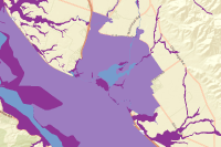
|
| GUID | N/A |
| Name | USA_Flood_Hazard_Areas |
| Title | USA Flood Hazard Areas |
| Type | Map Service |
| Type Keywords | ArcGIS Server, Data, Map Service, Metadata, Service, WMTS, Hosted Service |
| Description | The Federal Emergency Management Agency (FEMA) produces Flood Insurance Rate maps and identifies Special Flood Hazard Areas as part of the National Flood Insurance Program's floodplain management. Special Flood Hazard Areas have regulations that include the mandatory purchase of flood insurance. Dataset Summary Phenomenon Mapped: Flood Hazard Areas Coordinate System: Web Mercator Auxiliary Sphere Extent: Contiguous United States, Alaska, Hawaii, Puerto Rico, Guam, US Virgin Islands, Northern Marianas Islands and American Samoa. Visible Scale: The layer is limited to scales of 1:1,000,000 and larger. Use the USA Flood Hazard Areas imagery layer for smaller scales. Source: Federal Emergency Management Agency Publication Date: August 31, 2020 This layer is derived from the August 31, 2020 version of the National Flood Hazard Layer feature class S_Fld_Haz_Ar. The data were aggregated into eight classes to produce the Esri Symbology field based on symbology provided by FEMA. All other layer attributes are derived from the National Flood Hazard Layer. The layer was projected to Web Mercator Auxiliary Sphere and the resolution set to 1 meter. To improve performance Flood Zone values "Area Not Included", "Open Water", "D", "NP", and No Data were removed from the layer. Areas with Flood Zone value "X" subtype "Area of Minimal Flood Hazard" were also removed. An imagery layer created from this dataset provides access to the full set of records in the National Flood Hazard Layer. A web map featuring this layer is available for you to use. What can you do with this Feature Layer? Feature layers work throughout the ArcGIS system. Generally your work flow with feature layers will begin in ArcGIS Online or ArcGIS Pro. Below are just a few of the things you can do with a feature service in Online and Pro. ArcGIS Online Add this layer to a map in the map viewer. The layer is limited to scales of approximately 1:1,000,000 or larger but an imagery layer created from the same data can be used at smaller scales to produce a webmap that displays across the full range of scales. The layer or a map containing it can be used in an application. Change the layer’s transparency and set its visibility range Open the layer’s attribute table and make selections and apply filters. Selections made in the map or table are reflected in the other. Center on selection allows you to zoom to features selected in the map or table and show selected records allows you to view the selected records in the table. Change the layer’s style and filter the data. For example, you could change the symbology field to Special Flood Hazard Area and set a filter for = “T” to create a map of only the special flood hazard areas. Add labels and set their properties Customize the pop-up Use in analysis tools to discover patterns in the data ArcGIS Pro Add this layer to a 2d or 3d map. The same scale limit as Online applies in Pro Use as an input to geoprocessing. For example, copy features allows you to select then export portions of the data to a new feature class. Areas up to 1,000-2,000 features can be exported successfully. Change the symbology and the attribute field used to symbolize the data Open table and make interactive selections with the map Modify the pop-ups Apply Definition Queries to create sub-sets of the layer This layer is part of the Living Atlas of the World that provides an easy way to explore the landscape layers and many other beautiful and authoritative maps on hundreds of topics. |
| Tags | environment, landscape, esri_environment, hosted, FEMA, NFHL |
| Snippet | This feature layer displays Flood Hazard Areas from the Flood Insurance Rate Map created by the Federal Emergency Management Agency. (Feature layer has been clipped to the Monterey County boundary) |
| Extent | [-121.72575758381124, 36.62289430778527] - [-121.5534324795719, 36.75301434599806] |
| Spatial Reference | WGS_1984_Web_Mercator_Auxiliary_Sphere |
| Access Information | Source: FEMA, Esri |
| Classification | N/A |
| License Information |
|
| Culture | en-us |
| Properties | N/A |
| Advanced Settings | N/A |
| Url | https://salinas-gis.ci.salinas.ca.us/hosting/rest/services/Hosted/USA_Flood_Hazard_Areas/MapServer |
| Proxy Filter | N/A |
| Last Modified | N/A |
| Size | 0 |
| Documentation | N/A |
| App Categories | N/A |
| Industries | N/A |
| Languages | N/A |
| Listed | false |
| Comments Enabled | true |
| # Comments | 0 |
| # Ratings | 0 |
| Avg. Rating | 0.0 |
| # Views | 56 |
| Categories | /Categories/View Layers/View |
| Content Status |

Child Resources: Comments Rating Groups Item Data as Zip Item Dependencies
Supported Operations: Add Comment Add Rating Delete Rating Related Items Share Item Unshare Item Package Item Set Item Content Status